Home Builder Confidence At Highest Level in 12 Years

The home building market has seen its share of problems in the last decade, but home builder confidence has risen to its highest levels in 12 years.

According to an article on CNBC:

A monthly index of builder sentiment jumped six points to the highest level in 12 years. The National Association of Home Builders/Wells Fargo Housing Market index hit 71 in March, a sizable jump from 58 in March of 2016. Anything above 50 is considered positive sentiment.

“Builders are buoyed by President Trump’s actions on regulatory reform, particularly his recent executive order to rescind or revise the waters of the U.S. rule that impacts permitting,” said NAHB Chairman Granger MacDonald, a home builder and developer from Kerrville, Texas.

Builders are not only pleased with Trump’s first move on water, they also expect further deregulation to bring down construction costs. There are, however, other roadblocks keeping the nation’s builders from producing more homes, which are sorely needed in today’s tight housing market.

source: http://www.cnbc.com/2017/03/15/home-builder-confidence-soared-to-highest-level-in-12-years-as-trump-rolls-back-regulations.html

3D printing concrete

There are a lot of recent technologies that have impacted the civil engineering, land surveying and construction industries. Technologies such as GPS, machine control and drones just to mention a few.

Another new technology that could revolutionize the construction industry is 3D printing.

According to Wikipedia, 3D printing is defined as:

“3D printing, also known as additive manufacturing (AM), refers to processes used to synthesize a three-dimensional object in which successive layers of material are formed under computer control to create an object.”

The 3D printing industry is starting to develop technology to use concrete as the material for making objects. The article 3D Printers Can Now Print Concrete from the website Curbed explains how one university is printing concrete structures.

This video was included in the article linked above, and describes the 3D printing process for concrete structures:


Septic System Pressure Testing Recently Conducted

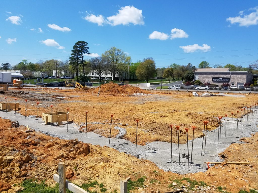
In previous posts, we’ve discussed the low pressure pipe (LPP) subsurface sewage disposal system (SSDS) designed by LandTech Engineering & Surveying for the Sunshine Acres Campground in Newport, TN. This week, we conducted a pressure test to confirm the LPP system operates as designed.

According to the EPA LPP System Fact Sheet :

“A LPP system is a shallow, pressure-dosed soil absorption system with a network of small diameter perforated pipes placed in narrow trenches.”

A LPP system is a good alternative for land development projects without public sanitary sewer systems available.

The Tennessee Department of Environment & Conservation (TDEC) requires level trench bottoms, 18″ to 22″ deep, 12″ wide, and spaced with a minimum of 5′ center to center spacing.  The perforated pipe diameters typically range from 1″ to 2″, with a minimum 3′ pressure head (1.3 pounds per square inch) at the end of the pipe.

The system pressure is tested by placing a 3′ vertical height pipe at the end of the perforated pipe. Gate valves are operated in the pipe system to adjust the system pressure until water just starts to flow out of the 3′ vertical pipe segment.

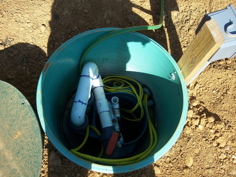
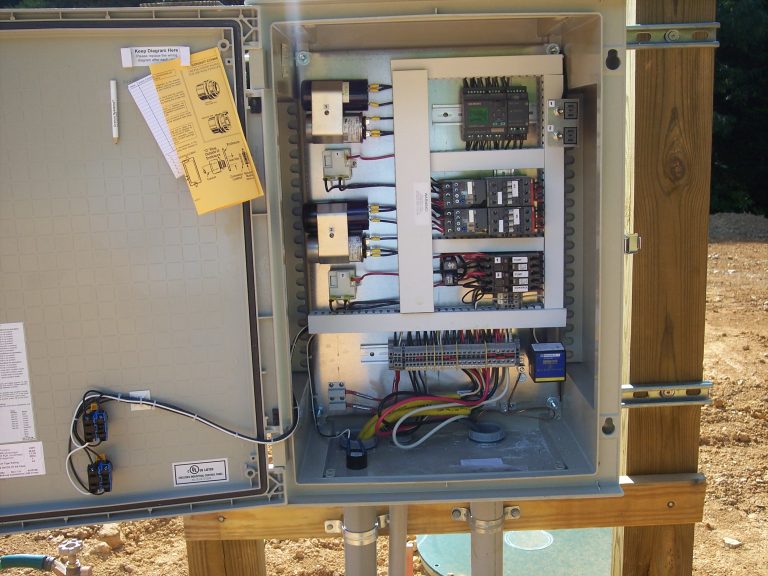
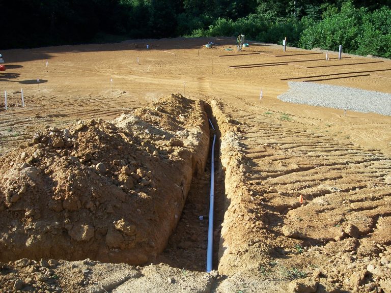
Below are photographs from the system test.

1. Photo – Pump tank riser:

pump tank riser


2. Photo – Pump control panel:

control panel


3. Photo – Force main pipe from pump tank to disposal field:

pressure main


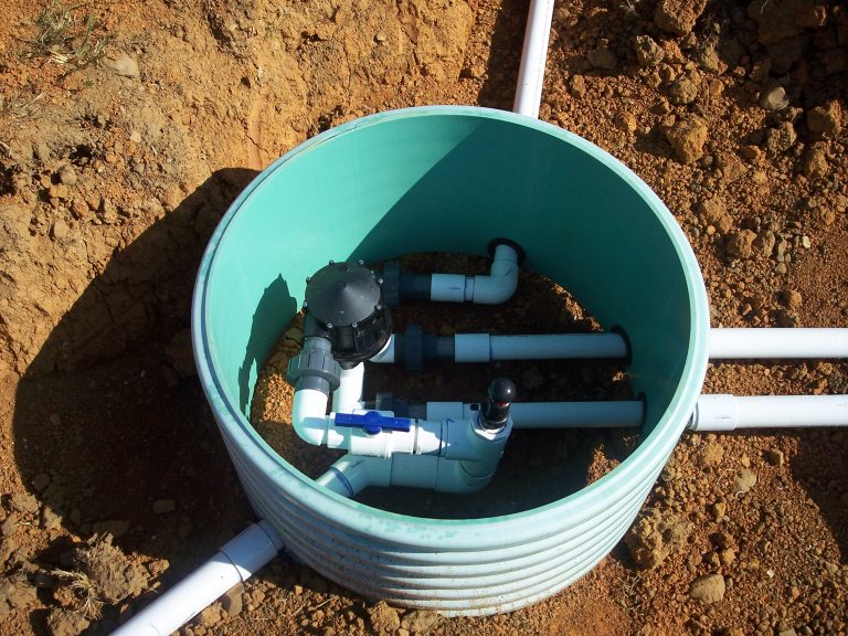
4. Photo – Automatic distribution valve (ADV) that diverts flow from pump tank to manifold pipes at disposal field cells:

ADV


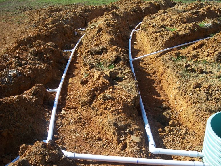
5. Photo – Manifold pipes from ADV to disposal field cell trenches:

manifold


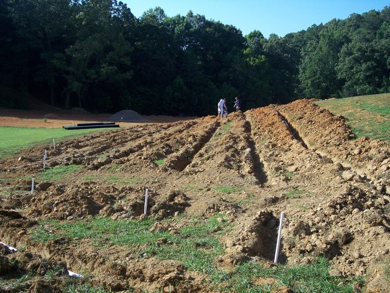
6. Photo – Disposal field trenches with 3′ vertical length pipe segments at each end for pressure testing:

disposal field

As an engineer, it’s always satisfying to see a system work as designed.

Please contact us if you’d like to discuss LPP systems or your land development project. http://landtechco.com/contact_us

Geopier Rammed Aggregate Pier Systems

LandTech has gotten the opportunity to work on a wide variety of projects that has exposed us to unique construction technology. We’re performing construction surveying stakeout of a project that is utilizing a Rammed Aggregate Pier (RAP) system.

Geopier Foundation Company, a subsidiary of the Tensar Corporation, developed the first RAP system in 1989. According to their website:

Geopier Rammed Aggregate Pier™ (RAP) systems are efficient and cost effective Intermediate Foundation® solutions for the support of settlement sensitive structures.

Geopier® technologies are constructed by applying direct vertical ramming energy to densely compact successive thin lifts of high quality crushed rock to form high stiffness engineered elements. The vertical ramming action also increases the lateral stress and improves the soils surrounding the cavity, which results in foundation settlement control and greater bearing pressures for design.

Depending on site requirements, RAP systems can be installed using replacement or displacement methods. The unique installation process utilizes vertical impact ramming energy, resulting in unsurpassed strength and stiffness. RAP systems are used to reinforce good to poor soils, including soft to stiff clay and silt; loose to dense sand; organic silt and peat; variable, uncontrolled fill; and soils below the ground water table.

See more at: http://www.geopier.com/Geopier-Systems/Rammed-Aggregate-Pier-Systems


Federal Court Blocks EPA Water Rule

The EPA and U.S. Army Corps of Engineers (USACoE) have been working to more clearly define the federal government’s authority to protect waterways by clarifying the definition of “waters of the U.S.”. However, there has been much disagreement about the limits of federal authority versus state authority and private property rights.

A Federal Court has handed down a stay on the new rule by the EPA and USACoE, saying it is likely illegal. http://thehill.com/policy/energy-environment/256493-court-blocks-obamas-water-rule-nationwide

 A federal court ruled Friday that President Obama’s regulation to protect small waterways from pollution cannot be enforced nationwide.

In a 2-1 ruling, the Cincinnati-based Court of Appeals for the Sixth Circuit delivered a stinging defeat to Obama’s most ambitious effort to keep streams and wetlands clean, saying it looks likely that the rule, dubbed “waters of the United States,” is illegal.

“We conclude that petitioners have demonstrated a substantial possibility of success on the merits of their claims,” the judges wrote in their decision, explaining that the Environmental Protection Agency’s new guidelines for determining whether water is subject to federal control — based mostly on the water’s distance and connection to larger water bodies — is “at odds” with a key Supreme Court ruling.

These issues are important to civil engineers working on land development projects because it will determine if the regulating authority is the federal government (EPA and/or USACoE), the state (TDEC in Tennessee), or the local government (City of Knoxville for example).

For the State of Tennessee, rules regarding work in waterways are generally regulated by the Tennessee Department of Environment & Conservation (TDEC). For example, anyone proposing to alter a stream, river or lake must obtain an Aquatic Resource Alteration Permit (ARAP). Examples of work requiring a permit include dredging, streambank stabilization, channel relocation, water withdrawals, and road crossings. For more information, visit TDEC’s website https://www.tn.gov/environment/article/permit-aquatic-resource-alteration-permit

Please feel free to contact LandTech’s staff of civil engineers and land surveyors to assist you with any issues relating to ARAP permitting. http://landtechco.com/home


Surveyors and Engineers – Call before you dig

Most people are familiar with the warnings to “call before you dig”. There are commercials, bumper stickers, and notices on websites. But, it’s not just a contractor digging a trench that needs to be concerned about underground utility damage. Land surveying work preparing maps for civil engineering design could also present a danger to underground utilities.

Prior to excavation you would call Tennessee 811.  http://www.tenn811.com/

“In the state of Tennessee, State Law requires anyone about to engage in either digging, excavation, moving of earth, demolition or any type of activity that disturbs the earth and therefore possibly involving a danger to damaging underground utility lines,  to notify Tennessee 811, of their intent to dig.

Tennessee 811 will then notify the member utilities of your proposed work. The utility company locator will then have 72 hours, excluding holidays and weekends, to locate those underground facilities. “

The Tennessee State Law is the “Underground Utility Damage Prevention Act”, and can be found in it’s entirety here: Underground Utility Damage Prevention Act

For LandTech projects it is standard practice to contact TN811 for a “design locate request” which is “a communication to the one‐call service in which a request for locating existing utility facilities for predesign or advance planning purposes is made“.

We will enter our design locate request using the E-Ticket process on-line. We will indicate the type of work as “survey work” or “survey stakes”. Since we may set 18″ length iron rods for property corners or survey measurement points, there is the potential to damage an underground utility line.

We would be happy to discuss our underground utility location process with you. Contact us at http://landtechco.com/contact_us

CAD Software update

We’ve been using Carlson’s 2016 civil engineering and land surveying software, running on IntelliCAD version 8.1,  for about two weeks. So far we’ve been pretty impressed with the improvements over previous versions.

IntelliCAD version 8.1 incorporates ribbon menus similar to AutoCAD, as well as many other new features found in AutoCAD. Likewise, Carlson Civil Suite 2016 had added enhancements to their road design, vehicle path tracking, and surface contouring.

We’re hoping to discover more new features as we continuing using the software.


Zoning Appeals

One of the earliest steps in the site design process is a review of the Zoning Ordinance to determine requirements for a particular property based on it’s zoning classification (such as residential, business, commercial, industrial, etc.) The Zoning Ordinance contains information that is relevant to both the land surveyor and civil engineer.

In Knoxville or Knox County, you can find the applicable zoning classification for a particular parcel using the KGIS website: http://www.kgis.org/KGISMaps/Map.htm

Once we’ve identified the zoning classification for a particular property, we will review the local zoning ordinance for a summary of the requirements.

For the City of Knoxville, you can review the Zoning Ordinance here:  https://www.municode.com/library/tn/knoxville/codes/code_of_ordinances?nodeId=APXBZORE

For Knox County, you can review the Zoning Ordinance here: http://archive.knoxmpc.org/zoning/KnoxCounty.pdf

If a proposed site design cannot meet all of the requirements for a particular zoning classification, the owner can apply for a variance. In Knoxville, an applicant submits a site plan to the City’s Plans Review and Inspections Division, and the requested variances are presented to the Board of Zoning Appeals (BZA) for an approval or denial of the requested variance.

You can find more information about the City BZA here: http://knoxvilletn.gov/government/boards_commissions/board_of_zoning_appeals/

You can find more information about the Knox County BZA here: http://www.knoxcounty.org/codes/bza.php

If you have any questions about zoning variance for your project, contact LandTech at http://landtechco.com/contact_us

Post Construction Certifications

An important step for a land development project is confirmation that the final site was constructed in accordance with the design plans. In the City of Knoxville, this step is called a Development Certification.

According to the City’s Land Development Manual, or LDM (website link LDM):

“An approved development certification is one of the items required prior to the release of any bond (also called Performance and Indemnity Agreement) that has been collected by the Stormwater Engineering Division. The development certification is issued by the Stormwater Engineering Division after all construction has been completed in accordance with the design plans and requirements of the Knoxville Stormwater and Street Ordinance.

Appendix A contains a site review checklist for final approval of a constructed site development project and the associated as-built drawing.

Every as-built drawing must be properly certified by the appropriate design professional engineer and the registered land surveyor.”

Therefore, the development certification involves both the civil engineer and the land surveyor.  Land Tech staff includes both professional civil engineers and registered land surveyors that can assist with the development certification process.

Contact us if you have any questions about this process for your project. http://landtechco.com/home