NASA has produced some fun “recruiting posters” intended to appeal to people needed in the future to help colonize Mars. In addition to teachers, builders, farmers, and technicians, surveyors are also singled out as needed for this mission Mars. We certainly agree that civil engineers and surveyors will be needed on Mars one day. I hope I can be present at LandTech’s grand opening of its new Mars office, or at lease attend by video conference from from Earth!
Here is the link to NASA’s site http://mars.nasa.gov/multimedia/resources/mars-posters-explorers-wanted/
Here is the specific NASA poster for recruiting surveyors:
Every once in a while I come across an interesting article that I think is of interest to the general engineering and surveying community. I just read a short Tech & Science article on the Newsweek website called “Scientists Create the Superman of Metals”, and thought I would share it on our blog.
A group of scientists say they have created the Superman of metals, a material so strong and lightweight it could lead to the creation of faster vehicles and revolutionize the airline and automotive industries.
Engineers at the University of California, Los Angeles, used a combination of ceramic silicon carbide nanoparticles and magnesium. The new metal boasts a stiffness-to-weight ratio that far surpasses other strong metals that engineers have reliably used for generations. The metal is also capable of absorbing and withstanding high heat without having its integrity altered.
Virtually every industry has been affected by computer technology, with civil engineering and land surveying being no exception. Land surveying field measurement procedures have been greatly enhanced from total stations with electronic distance measuring (EDM) and angle measurement, hand held data collection, and global positioning systems (GPS).
The use of computers has also revolutionized civil engineering and land surveying tasks in the office. Over time, the use of computers has evolved from more simple drawing tasks (computer-aided drafting, or CAD) to more sophisticated design tasks (computer-aided drafting and design, or CADD), and we typically use the term “CAD” to mean both computer-aided drafting and design software.
But, more specifically, what is CAD software? CAD is a computer software technology used for the preparation of drafting and design documentation in a two-dimensional (2D) and/or three-dimensional (3D) coordinate systems.
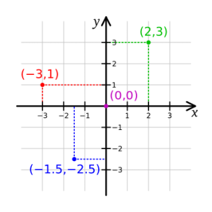
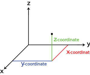
For example, property boundary plats are drawn in 2D space, and topographic survey maps or civil engineering plans with ground surface elevations are drawn in 3D space.
Below are images illustrating basic 2D and 3D coordinate systems.
2D Coordinate System3D Coordinate System
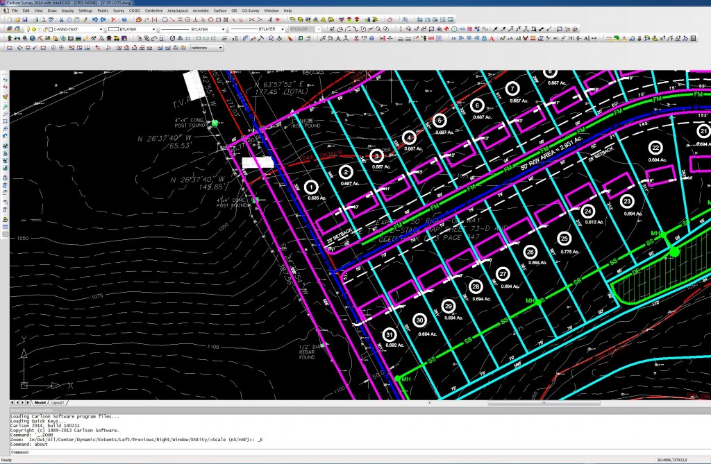
LandTech uses CAD software licensed and distributed by Carlson. Carlson software has modules specifically tailored for civil engineering and land surveying, making our design and drafting process more efficient than using a CAD platform alone. Below is a screen capture of a CAD drawing in Carlson software.
CAD Screen Capture
We would love to talk with you about how we can help you with your project. For more information, visit our website http://landtechco.com/contact_us
Surveyors have resurveyed a portion of the North Carolina-South Carolina boundary using modern methods and equipment, resulting in the state line being in a different location from where it had been assumed to be for hundreds of years. This news article presents an interesting story about the problems that arise from people not knowing where political boundaries lie. These problems mirror the issues that can occur when private property boundaries are unknown or assumed to be correct when they are not. Read about it below:
As a civil engineer, I’ve been accused of being frugal and smart (although my wife might describe me as cheap and smart-alecky ), but we ran across this story that seems to prove the stereotype of a civil engineer as true.
My goal when working on a civil engineering project is to prepare a design that makes sense and provides an economical solution. I think that’s what our clients expect when hiring a civil engineer…….smart and economical.
LandTech strives to provide this and more with our land surveying and civil engineering services. Contact us to discuss your project in more detail. http://landtechco.com/home
LightSquared, a startup wireless provider, has proposed a terrestrial-based wireless network using a portion of the electromagnetic spectrum previously reserved for satellite transmissions, and has petitioned the FCC for permission to do so. Because the portion of the EM spectrum licensed to LightSquared is directly adjacent to the portion used by GPS signals, LightSquared’s high-powered terrestrial antennas will likely “drown out” the relatively weak GPS satellite signals, seriously degrading the quality and effectiveness of GPS devices in the United States. If the FCC grants LightSquared’s petition and the network is implemented, it has the potential for severe adverse effects on the navigational ability of consumer, busines and military GPS devices. Please read the article linked below.