Building and utility infrastructure construction is a challenge in almost any circumstance. But what if you live in a lagoon?
We found this interesting video on YouTube about how Venice works. It’s very interesting, we hope you like it.
Building and utility infrastructure construction is a challenge in almost any circumstance. But what if you live in a lagoon?
We found this interesting video on YouTube about how Venice works. It’s very interesting, we hope you like it.
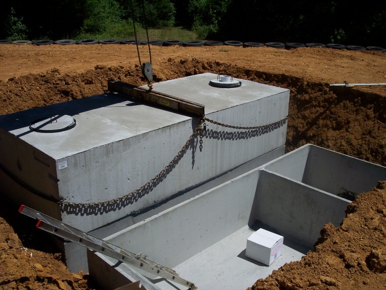
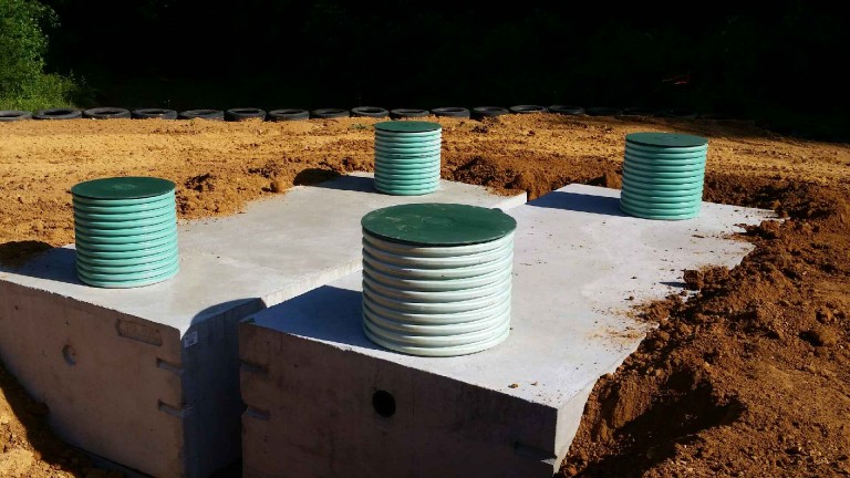
LandTech designed a low pressure pipe (LPP) subsurface sewage disposal system (SSDS) for the Sunshine Acres Campground in Newport, TN. The septic system construction permit for this project is issued by the Tennessee Department of Environment & Conservation (TDEC). More information about the permitting process can be found on TDEC’s website here:
https://tn.gov/environment/article/permit-water-septic-system-construction-permit
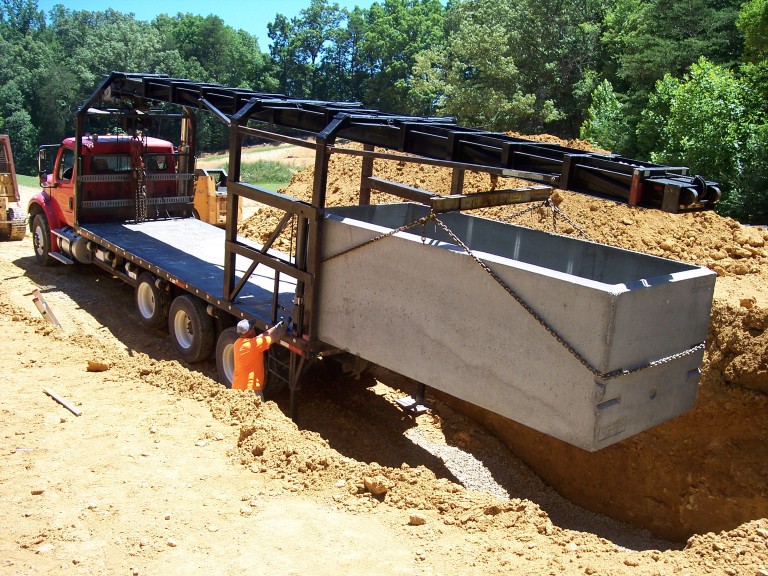
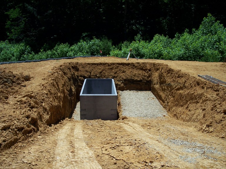
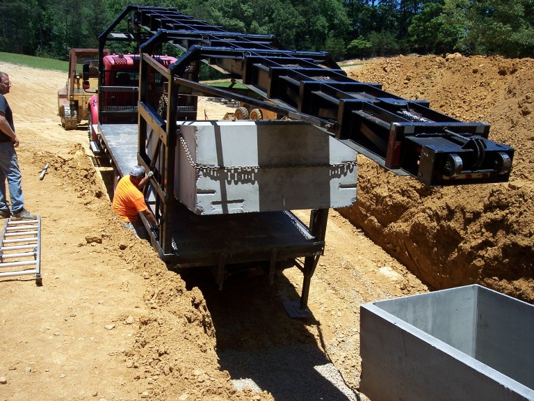
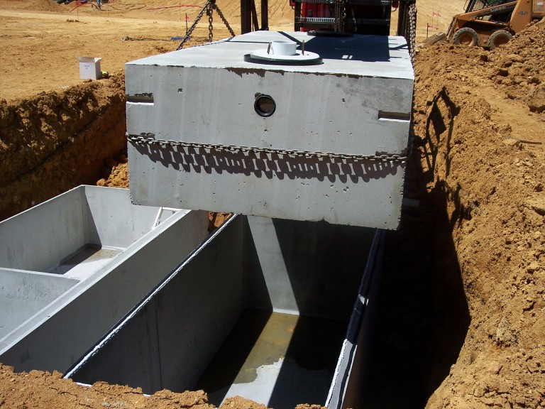
Construction of the system just began with installation of the septic and pump tank. Below are a few photographs of the tank installation.
Each tank was delivered by C.R. Barger & Sons in two pieces, a base and top section. The septic tank has a 3,000 gallon volume and weighs approximately 31,000 pounds. The pump tank has a 4,000 gallon volume and weighs approximately 34,000 pounds.
If you’re interested in learning more about this project, please contact LandTech, http://landtechco.com/home

Tennessee Vols became bowl eligible on Saturday, getting it’s sixth win against North Texas, winning 24-0. For game highlights, visit the UT Sports website: http://utsports.com/video/?2CdiXzOZOtU
Tennessee takes on Missouri this Saturday in Columbia, MO, trying to get their first win over the Tigers since joining the SEC.
The increasing popularity of unmanned aircraft systems (UAS), or drones, has prompted action from government regulators to increase the safety of their operation. Drones will soon require registration by the U.S. Department of Transportation (USDOT) and the Federal Aviation Administration (FAA), according to this article: http://www.cnet.com/news/us-department-of-transportation-will-require-drone-registration/
US Transportation Secretary Anthony Foxx announced today the creation of a task force that will develop a process for registering drones, also known as unmanned aircraft systems (UAS).
“The registration will reinforce the need for unmanned aircraft users, including consumers and hobbyists, to operate their drones safely,” Foxx said. “Registration gives operators the opportunity to learn the airspace rules before they fly and enjoy their devices safely.”
Currently, the Federal Aviation Administration (FAA) claims responsibility for the safety of US airspace from the ground up. For RC hobbyists (read: noncommercial pilots), the FAA safety guidelines limit recreational use of model aircraft to below 400 feet, within sight of the operator and more than 5 miles away from airports and air traffic without prior FAA notification. These guidelines fall in line with the National Model Aircraft Safety Code of the Academy of Model Aeronautics.
The FAA is also developing a mobile app for its No Drone Zone outreach program that will help pilots know if they’re location is safe for UAS flight or if they’re in a no-fly zone. This program is in addition to the FAA’s Know Before You Fly campaign, which outlines the current guidelines for drone flights.
Their has certainly been a lot of news about the commercial use of drones recently. See our recent blog post about FAA’s efforts to streamline the licensing approval process for drones, here: http://landtechco.com/blog/2015/10/19/land-surveying-drones/
The Tennessee Vols lost three of their previous four games after being up by 13 or more points. This past weekend, the Tennessee Vols got to turn the tables on the Georgia Bulldogs for a 21 point deficit come-from-behind win, 38-31.
This gives the Vols a 3-3 record at the season half-way mark, with a bye week on the schedule for this Saturday.
Game highlights can be found on the utsports.com website, here: UT-UGA Highlights
Stormwater management has seen numerous regulatory changes in recent years. Compliance has been a challenge to everyone in the land development industry.
To get the most up to date information on these regulatory issues, LandTech’s civil engineering and land surveying staff recently registered for the Tennessee Stormwater Association’s (TNSA) 2015 East Tennessee Development Symposium, to be held on November 18 and 19, 2015 at the Convention Center in Knoxville, TN. http://tnstormwater.org/blog/?page_id=740 According to the TNSA website:
TNSA continues to partner with other East Tennessee municipalities to offer a 2-day conference that we expect to attract 500 attendees working in all aspects of the development industry in East Tennessee including; planning, design, construction, financing, legal, BMP maintenance and operations, and regulatory compliance.
The topic areas include rules and regulatory requirements, site design process for the new 1″ runoff reduction requirements, economics of low impact development, and construction site management.
We hope to see the folks we work with on projects like these, including regulators, contractors and land developers.
For years, surveyors have used handheld computing devices for the collection of field data, putting us at the forefront of using mobile devices in an outdoor setting. For the past fifteen years or so, most handheld devices used by surveyors were hardware-software units based on Windows Mobile OS or its predecessors, with a specific app made just for the surveyor. However, small handheld mobile devices are now almost universal among business and individual users, and the market for rugged mobile devices for outdoor use has never been bigger. Surveying software vendors are now making their apps available for leading mobile OS platforms, such as Windows 8.1 and Androids. We are no longer tied to a particular hardware-software combination, so we may now select from a growing array of rugged mobile devices when choosing the device that best suits our needs.
At LandTech, we’re interested in more than just civil engineering and land surveying. We’re also big UT Vol football fans.
After being down by 14 points with less than 6 minutes left in the game, the Vols made a miraculous come back against the South Carolina Gamecocks this Saturday, to win 45-42 in overtime.
I’ve seen a lot of crazy finishes in college football, and this game will definitely be one I remember for a long time. For highlights, go to the UT Sports website: Video Highlights
The Vols have a bye next week, but return to Knoxville on November 15 against Kentucky.
We took a break from working on civil engineering and land surveying projects to watch the Tennessee Vols beat Utah State 38-7 at Neyland Stadium in Knoxville. It was a great night for football, and thankfully the rain stopped just prior to kickoff.
For highlights of the game, go to the UT Sports website: https://www.youtube.com/watch?v=j4I6u_yU29I
Most projects start with collecting basic information about the project site. Typically, one of the first places engineers and surveyors will go is a Geographic Information System (GIS) website.
You’ve probably heard of GIS, but may not know what it is. According to a major GIS software vendor, ESRI (http://www.esri.com/what-is-gis/overview#overview_panel):
A geographic information system (GIS) integrates hardware, software, and data for capturing, managing, analyzing, and displaying all forms of geographically referenced information.
GIS allows us to view, understand, question, interpret, and visualize data in many ways that reveal relationships, patterns, and trends in the form of maps, globes, reports, and charts.
Two popular GIS sites for getting information in Tennessee and Knoxville are:
You can find a lot of mapping and data by using search terms like property owner name or street address.
If you have any questions about your property or project contact LandTech and we’d be happy to help. http://landtechco.com/home